July 29 to August 12, 2017
This trip was a long time coming. The seed of inspiration for this trek on the John Muir Trail (JMT) was planted many years ago by my dad who led our family on many summer trips throughout the western US which instilled in me a love of the mountains and the great open spaces of the American West. Closer to home, we took some short (less than one week) backpack trips together in the Sierra which left in me an enduring, deep connection to the high mountains of California. A social studies film when young introduced me the trail, and I was later enthralled to read The High Adventures of Eric Ryback about his 1973 hike of the emerging Pacific Crest Trail from Mexico to Canada, whose highest points are shared by the JMT, immediately after graduating from high school.
Interest in both trails receded to the back of my mind as other interests and obligations arose, but more recently was rekindled while as an assistant scoutmaster when I was fortunate to meet up with like minded men and their sons who shared a love of backpacking and the wilderness, and we shared many trail miles talking about trips to come, one of the them the JMT. But schedules didn’t work out, our boys grew out of Scouting, and a while a few of us kicked around the possibility of putting a trek together, it never worked out. This brings us to last year, where something sparked in me an imperative to do it, even if I was to do it by myself.
I picked dates that would work for either of my sons should they want or be able to join me, and secured a permit. (Both actually wanted to join, but jobs and girlfriends understandably took priority.) I then set about to walk, hike and workout consistently for 6 months, often accompanied by Ginger our 4 year old labrador retriever who was always game for a hike, but who clearly questioned some 20 mile days. Fantastic care by chiropractor and massage therapist extraordinaire Peter Block who first cared for me as a racing masters cyclist, and several weeks under the care of acupuncturist Jeannette Schreiber to (successfully) address nagging plantar fasciitis from my big step up in workout volume, enabled me to progress and build good fitness and confidence to tackle the trail.
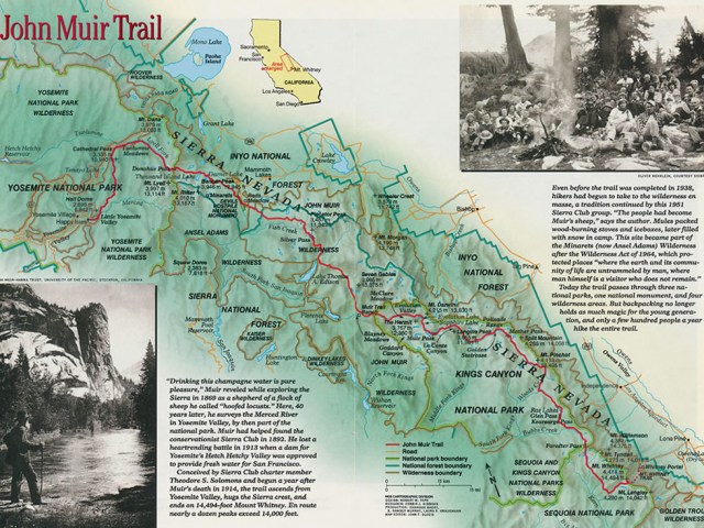

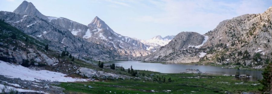
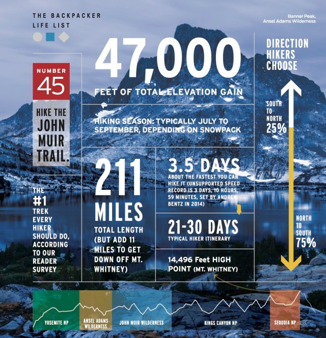
The JMT runs 211 miles from the Happy Isles trailhead in Yosemite Valley to the top of Mount Whitney. Supposedly about 75% of hikers hike from Yosemite south. It’s the traditional direction and provides time to acclimate to the higher elevations of the southern portion of the trail which culminates in the highest point in the continental US. I chose to start from the south and head north (NOBO in backpacking parlance). My reasoning was twofold; the lottery for permits from Yosemite is so packed there is close to zero chance of getting a specific desired start date, and I welcomed the physical challenge of starting at the high elevation. Game on from the start! I’d also chosen to do a two week itinerary for the entire trek, in part due to the realities of being a working professional, but also frankly for the added challenge.
Many of those who head NOBO start at Whitney Portal west of Lone Pine which is 10 miles from the Whitney summit. I chose to start further south from Horseshoe Meadows southwest of Lone Pine at the Cottonwood Pass trailhead. The trailhead is 28 miles from the Whitney summit, following the Pacific Crest Trail much of the way. Adding in a detour off the JMT to summit both Clouds Rest and Half Dome, and some other diversions for resupply, and so forth, total mileage for my trek was 249 miles, which I round to 250! An added plus is that my wilderness permit from this trailhead allowed me to summit Half Dome in Yosemite, normally limited to those lucky to get tickets by lottery due to its bucket list popularity. I’d start by summiting Mount Whitney close to the start and finishing (nearly) on Half Dome. Awesome!
My permit was from July 29 to August 12, normally in the sweet spot for hiking the high Sierra with most of the snow melted, rivers modestly high and less bugs. But adding – significantly – to the challenge in 2017 was a record, or near record, snow year in the Sierra. Nearly twice normal snowfall in 2016/2017. Mammoth Mountain, which the JMT skirts, received over 800 inches, and was still open for (limited) skiing when I started! Folks in the know said the season had effectively shifted 4 to 6 weeks, so July 29 was more like mid- to late-June where snow is still on the trails, and rivers still run a bit high.
Facebook groups that I followed on both the JMT and Pacific Crest Trail had harrowing stories about near-fatal, and in one case, fatal river crossings, and miles and miles of snow. Of this season’s Pacific Crest Trail hikers who opted for forge on into the Sierra (vs. skipping and coming back later in the season) they spent most of their time in snow which of course obscures the trail, dramatically slows pace, and requires excellent navigation/route finding for the duration, in addition to countless dangerously high river crossings as the record snow melted.
I followed these posts daily, praying that the end of July would have sufficient melt. By the end of June over 40% of the JMT was still covered in snow, but a heatwave in July boosted the melt, and reports nearer my planned departure date indicated far more limited snow cover. A backpacker who I follow on the web, and whose prior JMT itinerary inspired mine, did the trail just 3 weeks before me, and her pictures show dramatically more snow than I encountered. Her blog can be found at http://ladyonarock.com/category/john-muir-trail-2017/. Every day of melt counted, and for me, the trek was on!
Photo Album
I’ve summarized my trek by day, each with about 10 photos. A SmugMug album of the trip – with about 1,100 photos can be found here: https://phelps.smugmug.com/Dons-2017-JMT-Trek/n-g8PHfC/
